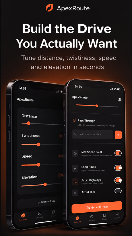
Tell ApexRoute how far you want to go and how twisty you want it, and it builds the drive — backroads, passes and coast roads instead of the fastest way there. Then it records the run so you can keep it.
50 famous roadsFree to startNo account neededNo ads, no tracking
🛣️ Twisties⛰️ Mountain🏖️ Coastal🌳 Backroad🌅 Scenic🌀 Hairpins🪨 Pass🛤️ B-road🎯 Apex hunt🌙 Night run🛣️ Twisties⛰️ Mountain🏖️ Coastal🌳 Backroad🌅 Scenic🌀 Hairpins🪨 Pass🛤️ B-road🎯 Apex hunt🌙 Night run
How it works
Phone in. Banger road out. In about 30 seconds.
No more dragging Maps around hoping for the good stuff. Set the shape of the drive you want, take it to your maps app, and keep what you drove.
01
Set the road, not the destination
Distance and twistiness, start and finish — your location, a typed address, or a point you pick on the map. Leave the finish blank for a loop. Avoid motorways and tolls if you'd rather.
02
Drive it in Google Maps or Apple Maps
ApexRoute hands the finished route to the maps app you already use for turn-by-turn. It doesn't try to be a sat-nav — it decides where you're going, and lets Maps do the talking.
03
Record it and keep it
The recorder tracks the drive from your phone's GPS. On iPhone it shows on the Lock Screen and Dynamic Island as you go; on Android it's a notification. Rate it, pin a memory marker, send it to a mate as a link.
Why it works
Built by drivers. Not by route planners.
A road book of 50
Five packs — UK & Ireland, the Alps, Europe, North America and Around the World. Open a road and ApexRoute sets it up as a route you can generate. Five are open to everyone, one in each pack.
Start anywhere, finish anywhere
Plan from where you're standing, from an address you type, or from a point you drop on the map. Set a finish for an A-to-B, or leave it off and get a loop back to the start.
Twisty on purpose
Distance and a twistiness setting shape the route. Switch on Scenic Route and it steers the waypoints toward viewpoints and scenic roads instead of whatever is quickest. Free, and off until you ask.
Record the drive
GPS trace, speed, distance, duration and elevation, saved on your phone. Rate a road for twistiness, scenery and surface, and pin memory markers with a note or a photo where something happened.
Time behind the wheel
Lifetime totals — distance, hours, drives — are free. Personal records and month-by-month and year-by-year breakdowns come with Pro. Counted from drives you actually recorded.
Send a route as a link
The link carries the route itself — no account, no server, nothing stored at our end. Whoever you send it to sees the drive whether or not they have the app. Free in both directions.
The road book
Fifty roads worth the detour:
Real roads, grouped into five packs. The Cat and Fiddle, Furka Pass, Sa Calobra, Tail of the Dragon and the Great Ocean Road are open to everyone — one in each pack. The other forty-five come with Pro.
🌀
Cat and Fiddle
Cheshire / Derbyshire · 19 km
🪨
Passo dello Stelvio
South Tyrol / Lombardy · 49 km
⛰️
Transfăgărășan
Făgăraș Mountains · 90 km
🌀
Tail of the Dragon
Tennessee / North Carolina · 18 km
🏖️
Great Ocean Road
Victoria, Australia · 240 km
🌅
Bealach na Bà
Wester Ross, Scotland · 18 km
🪨
Furka Pass
Uri / Valais · 17 km
🌙
Hakone Turnpike
Kanagawa, Japan · 14 km
Pricing
Free to start. Pro when you want the rest.
The App Store and Google Play show the current price in your own currency, and ApexRoute reads it live from them — so there is nothing here to go out of date. Monthly, annual and one-off lifetime options.
Free
Free
Enough to find a good road this weekend, without an account.
No ads on either tier. Cancel a subscription any time in your Apple ID or Google Play subscription settings.
Why bother
The road is half the car. ApexRoute optimises for the half you remember.
Every other map is trying to get you there. Ask one for a good drive and it has no idea what you mean — so you end up scrolling satellite view looking for squiggles. ApexRoute asks for a distance and a twistiness instead, and builds the drive around them.
Routes come from a routing engine set to favour bends and gradient over speed, and Scenic Route pulls in viewpoints and scenic roads from OpenStreetMap to bias the waypoints. The road book is hand-picked rather than generated — fifty roads that earned their reputation, with the notes to explain why. Nothing needs an account, nothing is tracked, and there are no ads on either tier.
50
Famous roads in five packs, hand-picked and annotated — five of them open to everyone.
0
Accounts, ads and trackers. Drives and routes stay on your phone unless you share one.
1 link
A shared route travels inside its own link. There is no server holding it and nothing to look up.
FAQ
The basics.
Does ApexRoute navigate me, or do I still need Maps?
You still use Maps. ApexRoute is the part that decides where you're going — it works out a route worth driving, then hands it to Google Maps, or Apple Maps on iPhone, for turn-by-turn. It doesn't try to replace your sat-nav.
Does it work where I live?
Route generation isn't limited by country — you give it a start point and it plans from there. The road book is a curated set of fifty roads across five packs, so those specific roads are UK & Ireland, the Alps, wider Europe, North America and a round-the-world pack.
Does it work without a signal?
Partly, and it's worth being straight about it. Generating a route and drawing the map both need a connection — there are no offline maps. Recording a drive doesn't: the trace comes from your phone's GPS and is written to the phone, so a run through a valley with no bars still records.
What does drive recording actually capture?
The GPS trace, plus speed, distance, duration and elevation gained and lost. You can rate a drive for twistiness, scenery and road quality, and drop memory markers with a note or a photo. It doesn't measure lean angle or corner-by-corner telemetry.
Someone sent me an ApexRoute link — what is it?
A shared route. The whole route is encoded inside the link, so opening it in a browser shows you the drive, its distance and its shape even without the app. With ApexRoute installed the link opens straight in it, where you can save it to your library.
Can I import a route I made elsewhere?
Yes — GPX import and export are both there, and both are Pro. Import a GPX and it lands in your library; export any route to take it somewhere else.
What happens on my Lock Screen while I'm driving?
On iPhone (iOS 16.2 and up) a Live Activity shows the drive's elapsed time, distance and speed on the Lock Screen and in the Dynamic Island. On Android it's a notification that the drive is still recording, if you've allowed notifications.
Do I need an account? Are you tracking me?
No account, no sign-in, no analytics and no ads. Your routes, drives and photos live on your phone. The only thing that leaves it is a route you deliberately share, or the addresses and coordinates needed to plan a route in the first place.
Drive better.
Free to download, no account, no ads. iPhone and Android. Your next great road is one tap away.